To watch Deep Dive MH370 on YouTube, click the image above. To listen to the audio version on Apple Music, Spotify, or Amazon Music, click here.
For a concise, easy-to-read overview of the material in this podcast I recommend my 2019 book The Taking of MH370, available on Amazon.
Interested in connecting with a growing, passionate audience? Let’s talk. Email andy@onmilwaukee.com.
If the satcom was hacked and MH370 was taken north, the perpetrators presumably had a plan that ended with them alive, and this would have to involve landing the plane at an airport.
But is there an airport they could have landed at?
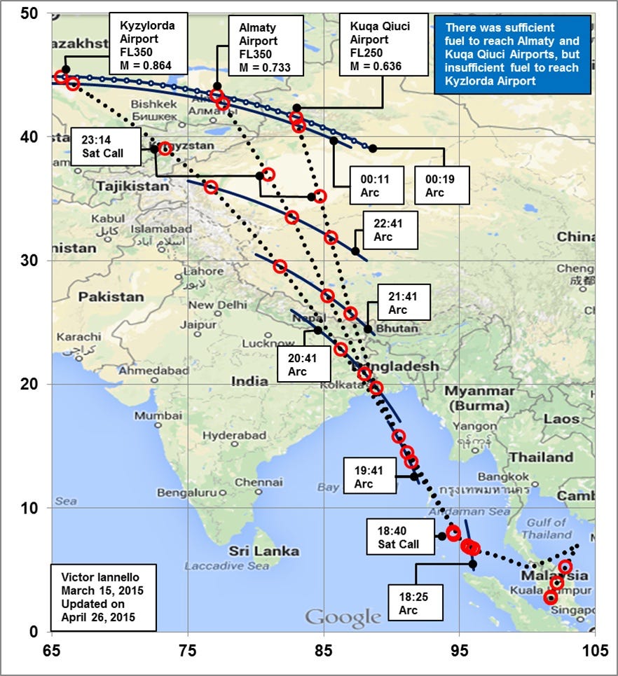
In Episode 13, we talked about how scientists at an Australian government organization called the Defense Science & Technology Group used Monte Carlo modeling to generate a large number of possible routes and see which ones matched the BTO data. They wound up with a probability distribution that looked like this:
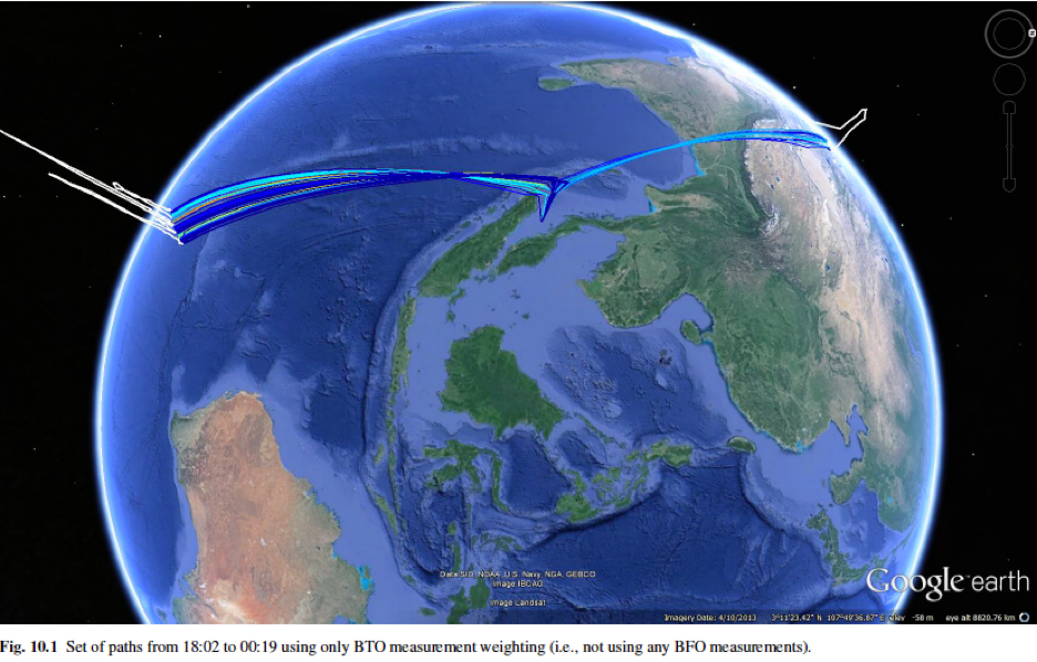
Based on the BFO data, they concluded that the plane had gone south. But we’re proposing that the data was spoofed to make it seem like the plane went south when it really went north. So we’re interested in this part:
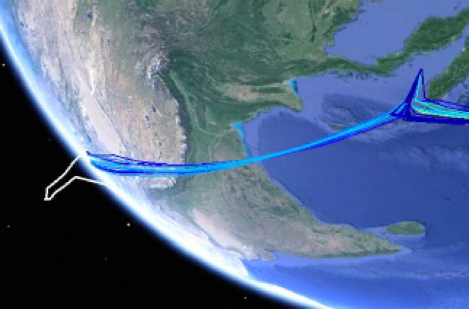
As you can see these paths all go across the Bay of Bengal, comes ashore west of Calcutta and the Ganges Delta, crosses Nepal and the Himalayas and then across Tibet and Xinjiang.
Eyeballing the places that these routes crossed, I tried to recreate them on Google Earth and came up with this:
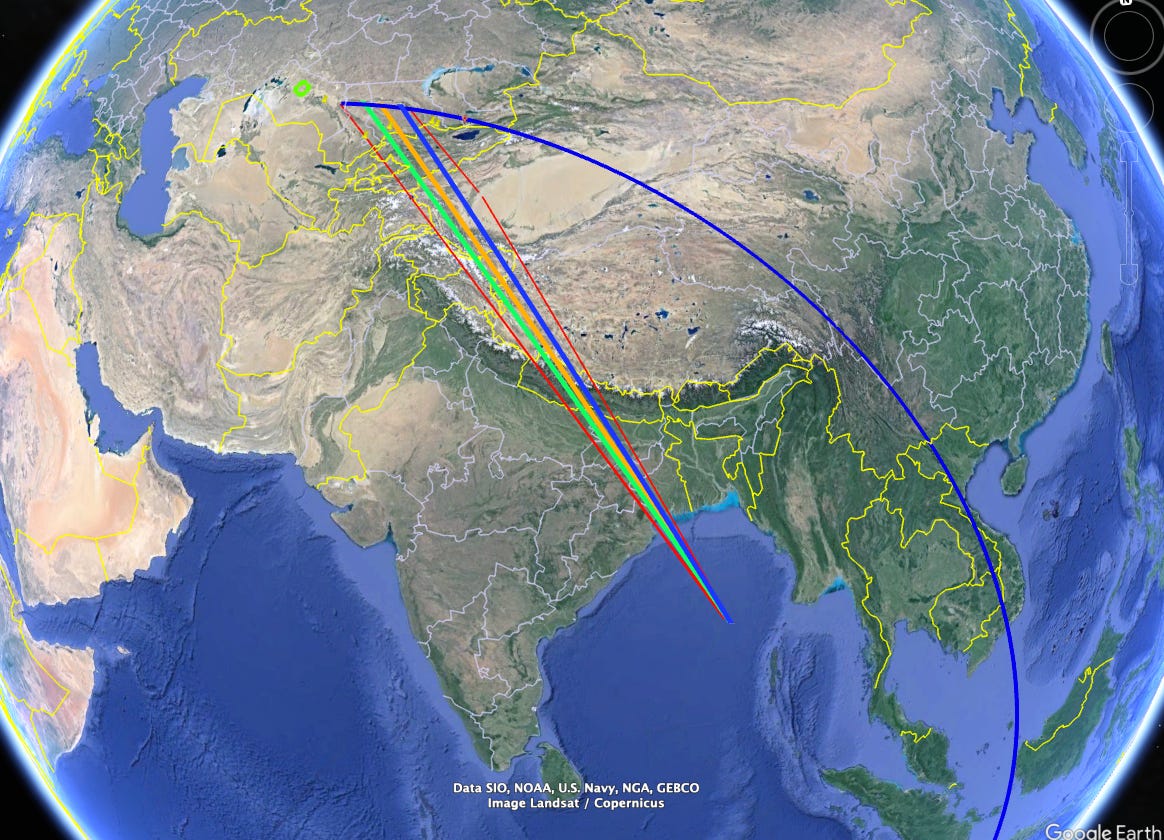
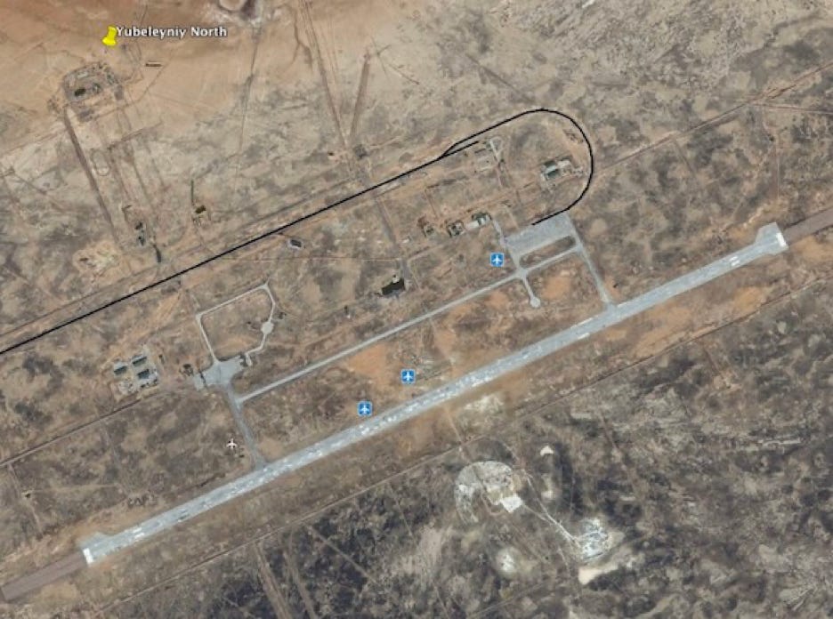
In Episode 13 we talked about the specifics of the countries these routes pass over and where various airbase are located, for now let’s focus on where these paths end up. Zooming in:
The red lines on the left and right are what I’ve eyeballed to be approximately the east and west edges of the DSTG’s probability distribution. The three colored lines represent routes that you get if you assume that the plane flew at speeds of 350 (blue), 400 (orange), and 450 knots (green). As you can see, the faster the plane flew, the further west it would have gotten.
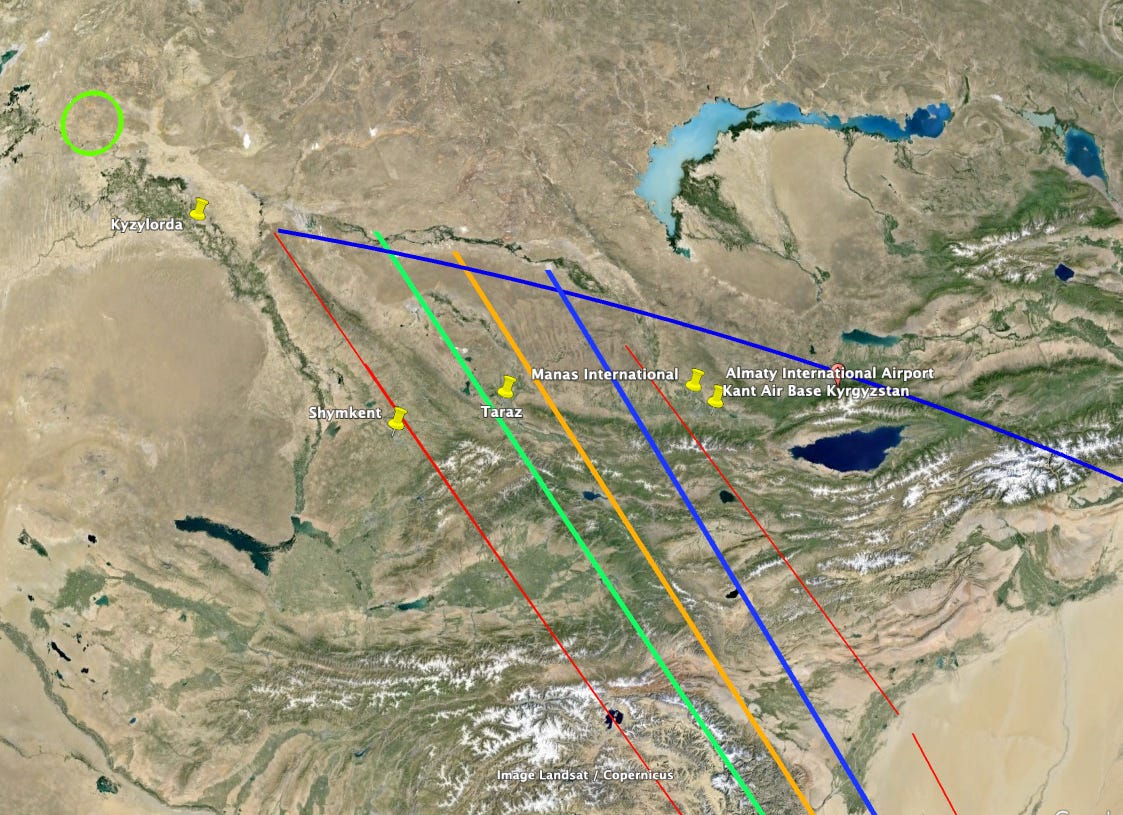
One of our audience members, Keelie, looked at the map we put up with Episode 13 and decided to search around the area and see what runways there might be that a 777 could land on. She found four that I’ve marked on the chart above: Kyzylorda, Shymkent, Taraz, and Manas. Except for Kyzylorda, they’re all south of the 7th arc, which I feel is pretty much disqualifying, since I find it hard to imagine that a plane that would be on the edge of running out of fuel would fly further than it needed to go.
What about Kyzylorda? It’s pretty intriguing, as it’s very close to being right on the 7th arc. But it’s a bit too far to the west, so MH370 might have had trouble getting there. I’d put it on the ‘maybe’ list though. Because there are a lot of uncertainties. For instance, if whoever took the plane did something called “step climbs” the flight would have been more efficient and hence able to fly further.
Here’s something interesting. Just beyond Kyzylorda is a green oval 56 km across. This is a rather remarkable place called the Baikonur Cosmodrome, where Yuri Gagarin became the first human being to reach orbit. Though it lies inside the borders of Kazakhstan, it is leased by Russia and functions as autonomous territory—a sort of Kremlin-controlled Guantanamo on the steppe, selected by the USSR at the dawn of the space age for its wide-open spaces and remote location.
Near the center of the oval lies a historically significant called airstrip called Yubileyniy, the Russian word for “Jubilee.”
Nearly 15,000 feet long, it’s the longest runway in Kazakhstan. It was built in the 70s as the landing site for the Buran space plane, the Soviet Union’s answer to the Space Shuttle. Constructed of special reinforced concrete twice as strong as that used in normal runways, and ground to exceptional flatness using special milling machines, Yubileyniy remains to my knowledge the only airstrip in the world that was built specifically for the use of self-landing aircraft. On November 15, 1988, after a successful three-hour trip in space, the unmanned Buran made its first and only landing at Yubileyniy, missing its landing mark by less than 50 feet. Soon after, the Soviet Union fell apart, and the project was cancelled. To this day, the area sits largely disused, far from the busy launch areas of Baikonur, surrounded by derelict buildings that haven’t been touched in decades.
Most large runways are located at airports near cities. Yubileyniy isn’t. And the fact that it was designed for a self-landing airplane is particularly apt considering that hijackers were chosen for their ability to steal a plane, not to fly it. Fortunately, the Boeing 777 flight management system is able to fly what’s known as an Instrument Landing System Category III “autoland” approach. Essentially, once the necessary information is plugged into the system, the plane is able to fly itself to any suitably equipped runway, with or without a trained pilot is at the controls.
After the shootdown of MH17 I was pretty convinced that Russia had had a hand in taking MH370, and Yubileyniy seemed a super-intriguing possibility for a landing spot. So I asked myself, could they have landed the plane there and hidden it?
As I scanned around in Google Earth, I didn’t see any building nearly big enough to park a 777 in. But then I stumbled on something interesting. About a mile from the airstrip was an abandoned building that had sat untouched for decades, just left to slowly crumble in the desert. Here’s how it looked in 2012:
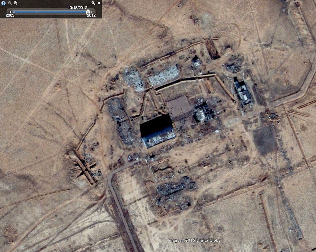
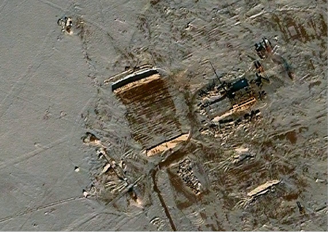
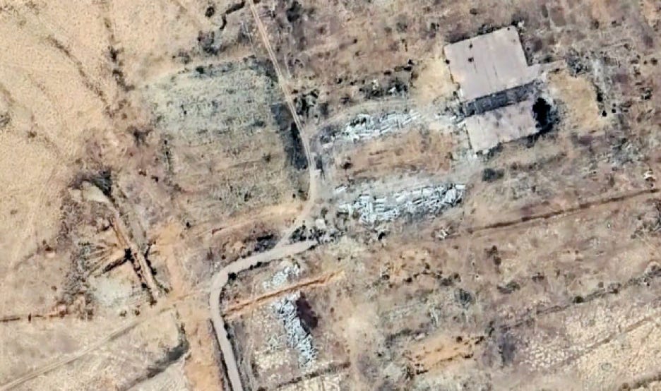
Then I found a source of digital satellite imagery called Terraserver with more up-to-date imagery. Come to find that after decades of neglect someone suddenly took an interest in this area. This is what it looked like in October 2013, five months before the plane disappeared:
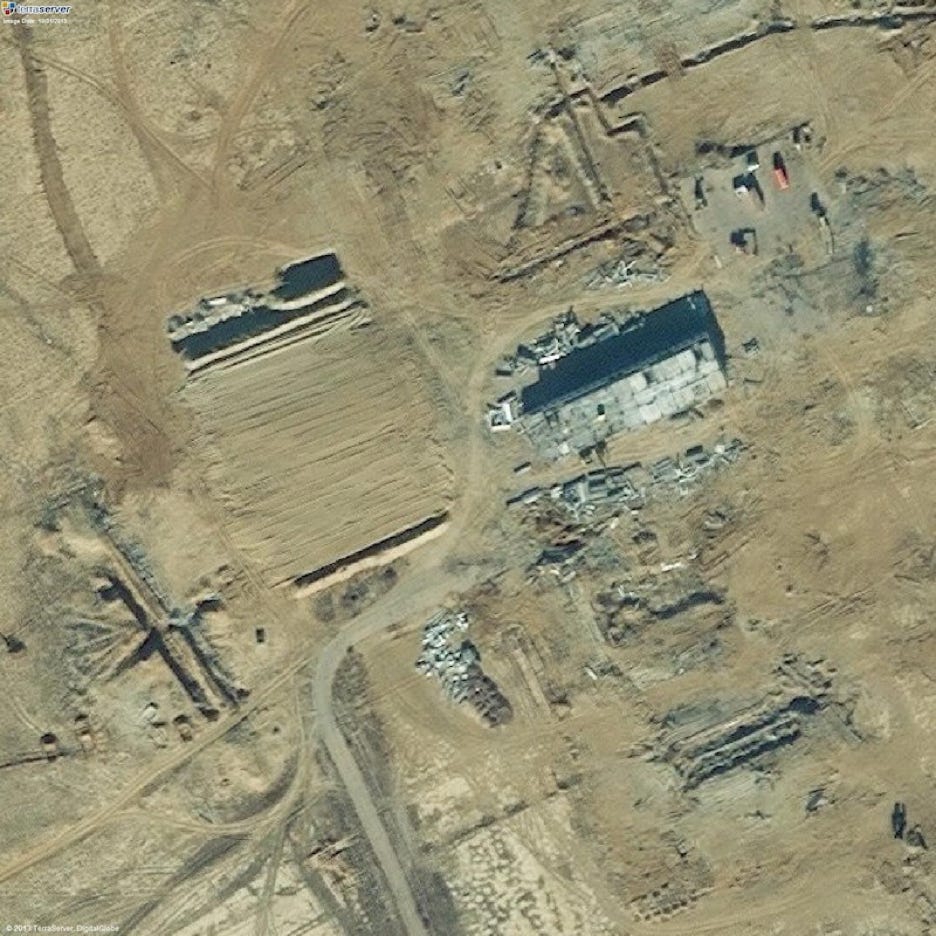
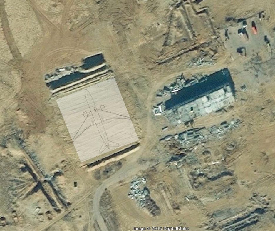
A number of trucks are lined up in the parking lot in the upper-right part of the image. The six-story building is being disassembled. And what looks like a large rectangle of dirt has been bulldozed to the left of the building. The image resolution is so good that you can make out what I take to be the stripes left by the bulldozer blade as it worked back and forth horizontally. At the northern end of the rectangle is a berm which casts a shadow to the north. At the far northeastern corner lies what appears to be a trench with a well-defined corner on the upper right, with treadmarks leading out of it toward the southeast. I’m not sure what this dirt rectangle represents — are they building a pile of dirt, or a hole? — but what really gets my attention is the size of the thing. To give you a sense of scale, I’ve superimposed an equivalently proportioned 777 silhouette onto the image:
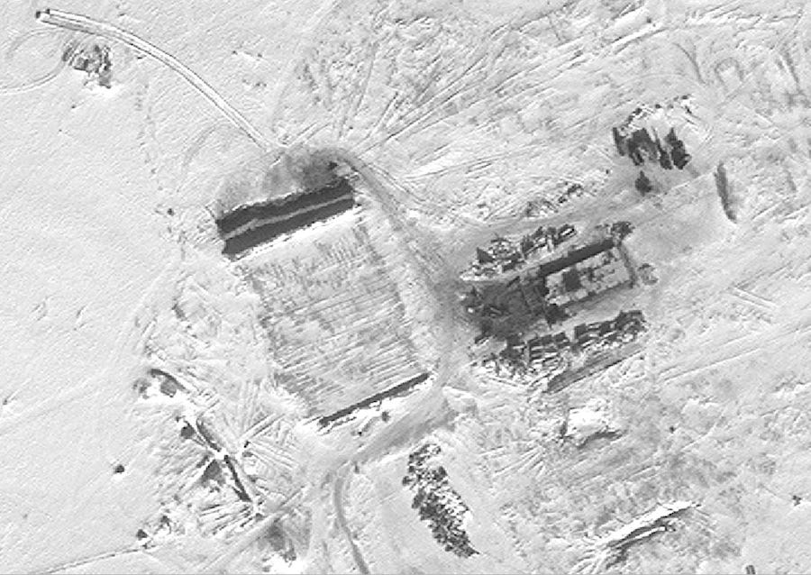
I got more images. Here’s what the area looked like in December 2013:
The sun is low on the snow-dusted steppe; it’s almost winter. In a month and a half, workers have removed all but the bottom-most floors of the six-story building. You can make out the shadow of a crane projecting to the north from the middle of the remaining structure. A handful of trucks can still be seen in the parking lot. The dirt pile has been extended a few yards to the north; the berm at that end now overlies the what we saw as the sharp corner of the trench in the October image. Beyond the berm lies either a dark strip that could either be a long trench or just a shadow; to my eye the line of brightness at its northern edge implies the lip of a trench, but who knows. Work is clearly continuing. The next image, in black and white, is from three weeks later, January 9, 2014:
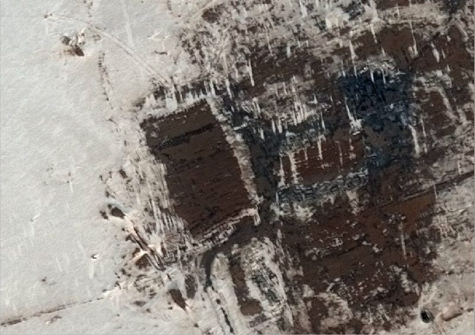
Here is two days before MH370 disappeared:
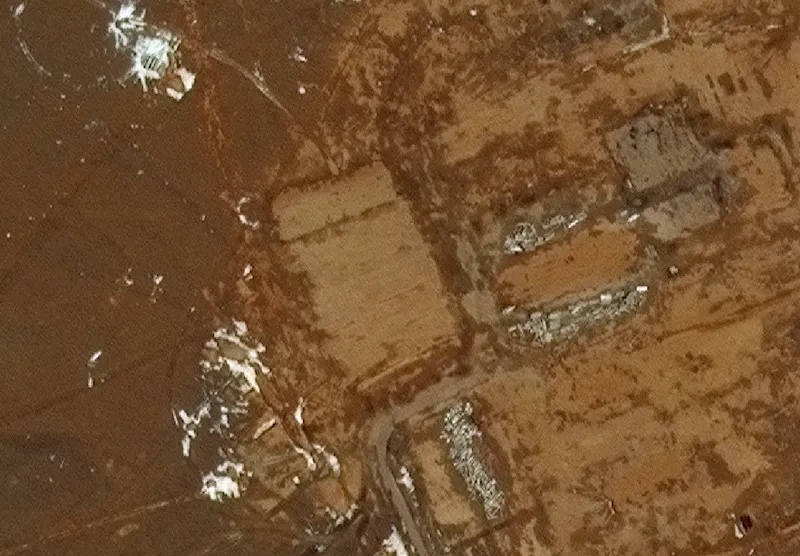
And eight days after:
This is what it looks like today:
I spent weeks in late summer 2014 downloading images, cropping them, rotating them, staring at them. For a while I was convinced that the images showed a large hole being dug, and then filled in after the plane disappeared. I looked into buying a plane ticket to Kazakhstan and getting a metal detector. But ultimately I decided that the images showed not a hole but a mound of dirt, and that it had not been disturbed after some time in February 2014.
I showed some of these images to construction experts and satellite imagery professionals, and received very little encouragement. Most likely, they told me, the work being performed was site remediation: a building was torn down, and construction debris thrown in a trench and covered up. As successive trenches are dug and filled in, a rectangular shape is formed. Simple as that.
And yet: the entire cosmodrome is littered with decades of abandoned equipment and derelict buildings, evincing a constitutional lack of interest in the concept of remediation. There is no commercial or residential activity for miles of Yubileyniy. Why, after decades, did the Russians suddenly need to clear this one lonely spot, in the heart of a frigid winter, finishing just before MH370 disappeared?
If you ask my opinion now, I think the construction of the Yubileyniy dirt pile is just one of those weird concidences. I don’t think that the Russians buried MH370 at Baikonur. For one thing, it would have been much simpler to just put more fuel in it, switch in a professional pilot, and fly it somewhere else, deep in the Russian interior.
For another thing, our old friend Victor Iannello spent a fair time puzzling overlanding places near the 7th arc and he focused on practical matters, like: where would the plane likely have enough fuel to go to?
What he found was that MH370 would have had a hard time reaching Kyzylorda, let alone Baikonur. However it would have had no problem reaching Almaty, the capital of Kazakhstan. The international airport there has the second-longest runway in Kazakhstan.
He wrote, “For the path to Almaty Airport at 35,000 ft, the required speed is M=0.735 and the average headwind is 10 kn, with a peak of 23 kn. The predicted fuel remaining at Almaty would be about 3,837 kg, or about 7.8% of the initial fuel load. Even with the uncertainties (-3.8%/+3.2%) of the fuel flow model, I predict there was sufficient fuel to reach Almaty.”
It’s worth noting, though, that Almaty seems to lie east of the pathways delineated by the DSTG. Since we don’t exactly how they generated their calculations, it’s hard to know how big of a problem that was.
One thing I find very intriguing about Almaty is how close it lies to the 7th arc:
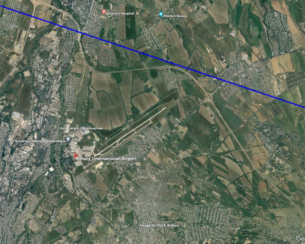
The distance is less than the length of the runway! It actually lies within the margin of error of the BTO data, so when it sent its final ping the plane could have been right there.
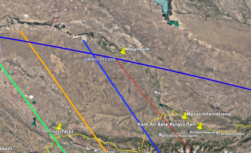
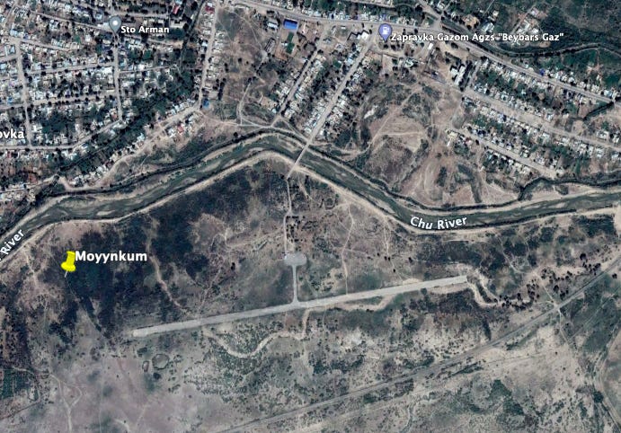
By the way: since I started working on this week’s episode, I noticed another interesting airstrip that also lies very close to the 7th arc, in this case just a few miles beyond it. And this one lies much closer to the DSTG’s high-probability zone. It’s called Moyynkum:
The upshot is that there are plausible places that MH370 could have landed in Kazakhstan, but we don’t really know where, and my suspicion is that if it did go north it was probably quickly refueled and then took off for a more secure location.
maybe you should watch or try to contact YouTuber “bald and bankrupt” he made and has posted a vlog (may 2022) https://www.youtube.com/watch?v=0fZ-r5Qe3tM where he was able to get into the Russian Baikonur Cosmodrome, he got a ‘taxi’ and then walked about 30 km across the desert-steppe. he managed to get into a large building and filmed the Buran (soviet version of us space shuttle)
Thanks for this! Back in 2014 when I first became aware of Baikonur and Yubileyniy I found social media posts by a Russian traveler who’d done something similar — he walked across the desert to Yubileyniy, came within a mile of the “dirt pile” and camped out overnight near the main airstrip, then walked to the Buran facility where was arrested (he wasn’t being very discrete). He was wearing an “I love Buran” t-shirt, I think the guards treated him quite well. I was looking into making travel plans myself but around that time became convinced that the dirt pile almost certainly couldn’t be the plane’s final resting place.